Kaua‘i
Near the geographic center of Kauaʻi is one of the wettest known places on earth, Mount Waiʻaleʻale. Despite this, wildfires can and do occur on the island. Steep slopes, rough terrain, difficult access, a large percentage of highly ignitable invasive grasses, and numerous threatened and endangered native species characterize the Kauaʻi landscape.
Ignitions occur regularly in the inhabited areas of the island, mostly near the coasts, where the landscape is dominated by current and former agricultural lands as well as grass and brush.


Kauaʻi is among the oldest high Hawaiian Islands and has been shaped by significant erosion, creating its dramatic landscape of valleys. Some of the steepest and least accessible areas include the North Shore to the West side, which also correspond strongly with the highest concentration of threatened and endangered species. This creates a challenging environment for reaching and containing fires when they occur, and presents a risk to the resident endangered species. >> READ MORE
After fires burn through an area of native vegetation in Hawaiʻi, the rebounding vegetation is generally dominated by fast growing non-native grasses and shrubs. Not only does this negatively impact biodiversity, but this can also contribute to erosion and the risk of landslides especially on the steep slopes of Kauaʻi.
The biggest large fires have historically occurred on the lee slope of the eastern flank of Waimea valley. This presents a concerning fire risk for the drought-prone community of Kekaha.
Kauaʻi is known for its high rainfall, but annual rainfall is not always a good indicator for risk. Particularly wet periods over a rainy season can, counterintuitively, significantly elevate hazard levels. Increased precipitation may lead to a surplus of vegetation growth, becoming potential fuel during subsequent drier periods, thereby elevating the risk of large wildfires. Given the changing wind and rainfall patterns arising from climate change, this may lead to increased risk for Kauaʻi.

Plans & Images


Recent Resources For Hawai‘i
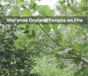
The native Hawaiian dryland forests of the Wai`anae Mountains are home to many unique species that are disappearing. Among the many threats facing dryland forests throughout the islands, the one that is perhaps most serious – and most preventable – is wildfire. (Produced by Outside Hawai’i, a program of Mālama Learning Center – 5 min)
Methodology of weed fire risk assessments. University of Hawai’i at Mānoa’s Kevin Faccenda and Curt Daehler developed a screening system focused on wildfire risk by asking land managers to assign a relative fire…
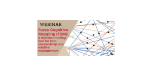
As Hawai‘i land managers know all too well, natural and cultural resource stewardship can be a daunting undertaking involving many stakeholders from different backgrounds taking into account complex social, cultural, and ecological considerations. In this webinar, UH Mānoa Masters student Rachael Cleveland demonstrates the utility of a decision support tool called Fuzzy Cognitive Mapping (FCM) which enables all stakeholders to create a “mental map” that can capture and compute the impacts of various decision-making scenarios on important resources. Land managers will learn how the FCM software works and its application to a wildfire group in Wai`anae, Hawai‘i whom she interviewed as part of her research.