A matter of perspective: Examining wildfire in the big picture and close-up
As we write this, Hawaii is shifting into its ‘winter season’ but despite ample rain in windward areas, there have been a run of fires over the past several weeks. The two most recently active were a fire in the Waianae Kai Forest Reserve on Oahu and another at Olowalu on West Maui. Patterns of fire occurrence across the state, year after year, reveal just how ‘flammable’ Hawaii’s landscapes have become. These patterns also point to the primary causes of fire in the state - introduced grasses and declines in plantations and ranching, periodic drought and dry conditions, and frequent, human-caused ignitions.
In addition to analyzing large patterns across multiple incidents, we can learn a great deal by examining individual fires. In July of 2013, the Pacific Fire Exchange (PFX) held its first official field trip, inviting partners from across the state to hear firsthand accounts of, and share lessons learned from, the 2010 fire which occurred off of Saddle Road next to Mauna Kea State Park on Hawaii Island.
The Mauna Kea 33 Fire
Officially known as the Mauna Kea 33 Fire, it burned over 1,300 acres of native mamane (Sophora chrysophylla) and naio (Myoporum sandwicensis) forest immediately adjacent to Mauna Kea State Park. This fire is important because it reveals the complexity and challenges of fire response, in addition to the vulnerability valued resources on the Hawaiian landscapes.

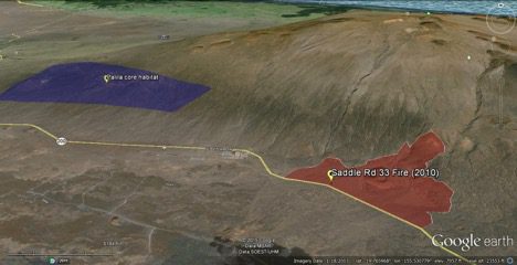
The fire occurred within the 60,000 acres designated as critical habitat for the Palila, an endangered Hawaiian honeycreeper with an estimated population of 1500-2400 birds (Camp et al. 2016).
Although Palila critical habitat encircles Mauna Kea, about 95% of the population is restricted to 15,000 acres located approximately 5 miles northwest from the flank of Mauna Kea 33 Fire. Firefighters were well aware of the direct threat posed to the birds, but the difficulty of the conditions involved on this fire – terrain, weather, and highly erratic fire behavior – reveals the limits of our ability to protect resources like this when fires occur.
The following narrative is based on a description of the incident led by Glen Timbal, Assistant Chief of Operations of the Fire and Emergency Services at the Army’s Pohakuloa Training Area (PTA) and Jay Hatayama, Protection Forester for Hawaii Island with the State Department of Forestry and Wildlife (DOFAW). Miles Nakahara, formerly of DOFAW and now with the Hawaii Wildfire Management Organization (HWMO) and Wayne Ching, the Fire Management Officer with DOFAW (now retired), also contributed to the account. Susan Cordell, Research Ecologist with the USDA Forest Service Institute of Pacific Island Forestry (USFS) provided insight into the ecological effects of the fire.
Incident Narrative:
On the morning of August 22nd, 2010, Chief of Operations Glen Timbal at PTA got a 911 call that a brushfire had ignited along Saddle Road. Arriving on scene, he noticed two columns of smoke along the north side of Saddle Road, one at mile-marker 33 and a smaller column further east. Chief Timbal sent one brushtruck after the smaller fire, while the rest of his company stayed at the first column. Back at the main fire, Chief Timbal quickly realized the fire was beyond the resources at hand so he called on suppression support from the Hawaii Country Fire Department and DOFAW, and on Civil Defense to close the highway. He also contacted the Mauna Kea Observatory to inform them of potential impacts from smoke.
As DOFAW began mobilizing its resources, County Fire worked on preventing hot-spots jumping to the south side of the Saddle Road while Chief Timbal’s PTA team attacked the main body of the fire to the north. The winds were highly erratic and the fire began spotting, spreading by embers on the wind, on both sides of the road. As the northward-moving head fire intensified, suppression efforts immediately shifted to containing the southern and western flanks of the fire. Bulldozers eventually arrived first to cut line (i.e., clear vegetation to stop the fire) to contain the spot fires south side of Saddle Rd and, as more arrived, to cut line along the east and west flanks.

Challenging Suppression Conditions: By the afternoon the fire had spread from Army property to State lands and command of the incident was divided between PTA and DOFAW fire crews.
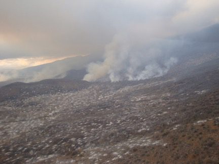
As the County Fire Department held the line along Saddle Road, the fire spread rapidly northward up the mountain, burning at very high intensity through dense vegetation – too hot and fast to send firefighters to the front or head of the fire. At one point, it burned across power lines and cut off landlines and nearly all cell phone signals – severely restricting communication among the fire crews.
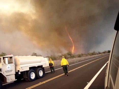
Erratic winds from the easterly trades and westerly thermals converging on the saddle between Mauna Kea and Mauna Loa created unpredictable and extreme fire behavior. During a briefing along the side of the road, Chief Timbal recorded startling footage of a fire ‘vortex’ with his phone.
Without access points to get firefighters safely in and out up on the mountain, the only available option was to hit the leading edge of the fire with water drops from helicopters, while firefighters worked to contain the flanks. At the height of the fire there were two Sikorsky “Sea-Stallion” helicopters from the marines, a medevac copter, two Blackhawk helicopters from the Hilo Air National Guard, and two Hughs 500s. Even with all this air power, the vegetation was so dry there was little impact made on the head of the fire as it continued to spread north and up Mauna Kea. Even as the winds died down in the afternoon and the head fire slowed, firefighters were never able to put in a line upslope, letting it burn out while crews worked the flanks.
Including the initial responders, about 100 firefighters responded with additional crews brought in from the Department of Defense on Oahu, the National Park Service, with DOFAW crews from Maui, Oahu, Kauai. It took one month to call the fire 100% contained – not spreading beyond its perimeter but still burning – and two months to call the fire controlled. The total cost of suppression is difficult to track across agencies, but cost DOFAW alone over $600,000 – twice the agency’s annual budget for fire management.
Impacts of the Fire

In the typically dry environment around Mauna Kea, vegetation recovery has been slow and will likely not return to the same pre-fire conditions in terms of plant community composition.
DOFAW Forester Jay Hatayama noted that the high severity of the burn brought on by drought conditions eliminated any chances of plants re-sprouting or regenerating from seeds in the soil. Hundreds of mamane and naio trees burned down through the root systems, requiring DOFAW and Army firefighters to dig out and extinguish underground fires for weeks after the initial fire front has passed.
Current research at the site by Susan Cordell with the USFS and part of the PFX leadership suggests that a dramatic loss of phosphorous from the soil after the fire – possibly due to wind erosion – may be further limiting plant growth.
It’s hard to quantify the direct impacts of Mauna Kea 33 Fire, but as Miles Nakahara, retired DOFAW wildlife biologists and incident commander put it, “I won’t see this forest come back in my lifetime.”
Lessons Learned
The primary limiting factor during the suppression effort was access. Firefighter safety is always the first priority, and there was no safe way to place firefighters or other resources like bulldozers to stop or slow the progression of the fire northward up the mountain.
During the PFX field trip, the firefighters stressed that had the wind shifted out of the east, there would have been very little chance of stopping the fire from encroaching on the core Palila habitat. Without established fuel breaks and access roads, the terrain was too difficult and the fire behavior too intense and unpredictable to defend the western flank between the active fire and core habitat area.
This incident highlights the critical importance of pre-fire mitigation efforts. Planning and infrastructure established in fire-prone areas can greatly assist firefighters and minimize fire impacts.
![Loxioides_bailleui A PALILA EATING MAMANE. BY PHOTOGRAPHER: JACK JEFFREY, USGS [PUBLIC DOMAIN], VIA WIKIMEDIA COMMONS](https://pacificfireexchange.org/wp-content/uploads/2022/08/Loxioides_bailleui.jpg)
Protecting resources as vulnerable and unique as the Palila will also require addressing some difficult questions that arose during the field trip:
-
Could a fire like this have been successfully contained within the core habitat given the current resources and infrastructure?
-
Would placing additional suppression resources closer to the area be enough to stop a future fire?
-
Can we effectively reduce fuels and increase access for firefighters within the core habitat without affecting the Palila population? Is this even an option?
Fire only becomes a threat when considered in the context of how it may impact the resources we value. The Mauna Kea 33 Fire provides a stark reminder that many of our most valued natural resources in Hawaii are highly vulnerable. It also serves to ground the expectations we have concerning the very difficult and dangerous work performed by our fire response agencies.
