Yap, Chuuk, Pohnpei, Kosrae
The FSM is an independent nation encompassing over 600 high islands and atolls comprising 270 square miles and spanning 1,600 miles east to west across the western Pacific Ocean. The islands are politically organized among four states associated with the four main island groups of Yap, Chuuk, Pohnpei, and Kosrae.
Human Habitation and Biodiversity
The region was settled by people several thousand years ago and evidence indicates the islands supported much higher population densities than at present with sophisticated agroforestry and fisheries management systems, many of which are still practiced at smaller scales today. The region is culturally and linguistically diverse and considered a biodiversity hotspot for its both marine and terrestrial ecosystems.


Human-caused Fire and Ecological Effects
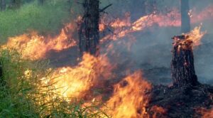
Fire-prone savannas occupy each of the main high islands in the FSM to varying extents and are derived from a long history of intentional burning by people. These savannas consist largely of native grasses, ferns, and shrubs and are interspersed among tropical forests and agroforests, forming complex, mosaic landscapes.
Seasonal and Climate Variability
Yap, the westernmost high island in the FSM, has the largest expanses of savanna vegetation and fires occur annually during the dry season from January to May. Savanna extent declines along with rainfall seasonality moving eastward towards Chuuk, Pohnpei and Kosrae, but extensive fires have been reported from these moister regions during extreme drought conditions such as occur during El Niño events.

 Julian Dendy")
Yap Wildfires
The U.S. Forest Service's Pacific Island Research center's Julian Dendy mapped the extent of wildfires from 2016 - 2022.

Recent Resources for the Western Pacific
In the aftermath of evacuation and recovery, communities and responders are often dealing with hazardous environmental conditions which call for vigillant public safety and environmental stabilization.
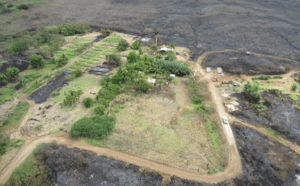
The role that farms and ranches play in land care is critical across fire prone landscapes. Ranches and farms keep fire-prone weeds at bay to maintain pastures and crops.
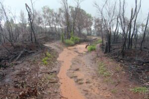
After human health and safety, the first priority is to protect the soils from rain and run-off.