The Republic of Palau comprises 250 islands at the western end of the Caroline Islands, approximately 500 miles due east of the Philippines.
Human habitation and Biodiversity
The island group was settled approximately 3,000 years ago and the current population is over 20,000 centered mostly in the city of Koror. Largely renowned for its marine ecosystems, Palau's terrestrial ecosystems are also biologically diverse with high rates of species endemism and relatively large tracts of intact tropical rain forest.


Human-caused Fire, Ecological Effects and Seasonal Influences
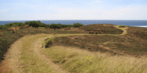
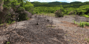
Fire-prone savannas, dominated by native ferns, grasses and shrubs, occupy nearly 15% of Babeldaob, the largest island of Palau. As elsewhere in Micronesia, these savannas were created and are maintained by intentional burning and create a complex forest-savanna mosaic landscape. Palau experiences drier conditions annually during March and April, during which fires are most common. Fire frequency and area burned increased dramatically during the severe drought associated with the 1998 El Niño event (2010 SWARS).
Palau Wildfires
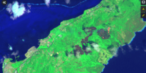
The US Forest Service’s Pacific Island Research center’s Julian Dendy has mapped the extent of wildfires from 2012 – 2022.


Recent Resources for the Western Pacific
A quick reference guide to establishing fuel breaks in tropical grasslands and savannas for reducing hazardous wildfire conditions on Pacific Islands.
This annual summary aims to provide a sense of context for wildfire activity on the Western US-Affiliated Pacific Islands (USAPI) of Palau, Guam, the Northern Marianas, and Yap.
This 2-page fact sheet explains the problem of wildfire on tropical islands as it intersects with watershed and marine resource health, invasive species, climate and weather. Tags: Hawaii, Climate &…