Hawai‘i – old
History of Fire
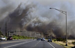
Over the past decade, Hawai'i has experienced an average of >1,000 ignitions burning >20,000 acres (8,000 ha) each year across the main inhabited islands. Fire response agencies are able to contain 90% of wildfire ignitions to less than one acre in size, but large fires (>1000 acres) have occurred on all islands, and happen multiple times each year across the state.


Large Fire Perimeter Data for Hawai'i
This data set contains polygons of wildland fire perimeters for the main Hawaiian Islands from 1999 to 2022. It compiles prior mapping efforts by different organizations with fires mapped from 2012 onwards by Dr. Clay Trauernicht ([email protected]) in the Department of Natural Resources and Environmental Management (NREM) at the University of Hawai'i at Mānoa. The data tracks and maps all fires greater than or equal to 20 hectares (50 acres), but some smaller fires are be included.
NOTE ON DATA USE AND DISTRIBUTION: We actively encourage use of this data set for scientific purposes and planning by communities, natural resource managers, and emergency response agencies. Users are prohibited from any commercial, non-free resale, or redistribution without explicit written permission from Clay Trauernicht. Download Fire Perimeters HERE
Wildfire Threats and Impacts
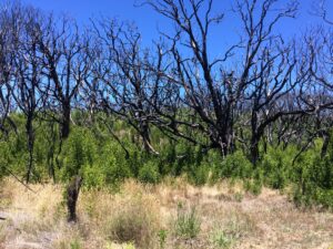
Nearly all fires in Hawai'i are human-caused and they often pose threats to communities and natural and cultural resources. Having evolved in the absence of frequent fires, Hawai'i's native ecosystems are particularly vulnerable to fire disturbance, which is often associated with the spread and establishment of nonnative grass and shrub species.
Wildfire Drivers
The primary drivers of fire occurrence are: frequent, mostly human-caused ignitions; expansion of nonnative, fire-prone grasslands and shrublands over c. 25% of state land area; and strong rain shadow effects and episodic drought create which create year-round fire weather.
Maps, Images & Factsheets


Recent Resources for the Western Pacific
Re-planting is an important, long-term strategy for soil stabilization. While native Hawaiian plants are always desirable, they require a great deal of care, such as water, fencing and weeding.
Members of our community from three islands will talk about their efforts in reducing the threat of wildfire across boundaries. Robbie Justice of Forest Solutions, Inc. on Hawai‘i Island, Jeremie Makepa of ‘Āina Alliance on Kaua‘i, and Erin Peyton of Paniolo Hale Firewise Committee on Moloka‘i share their lessons learned in reducing hazardous fuels and how agencies, landowners and residents can work together collectively.
In this joint webinar hosted by the Pacific Fire Exchange and the Pacific Regional Invasive Species Climate Change, we tackle the climate crisis in Hawai`i and how this affects the risk of wildfire as well as the impacts to people and the archipelago’s unique resources.